


- 42
- 182
Many thanks to @thresh for giving me the idea. I didn't want to overload you all with words and yapping as I am writing up something for Black Saturday 09 which I have personal experience in.
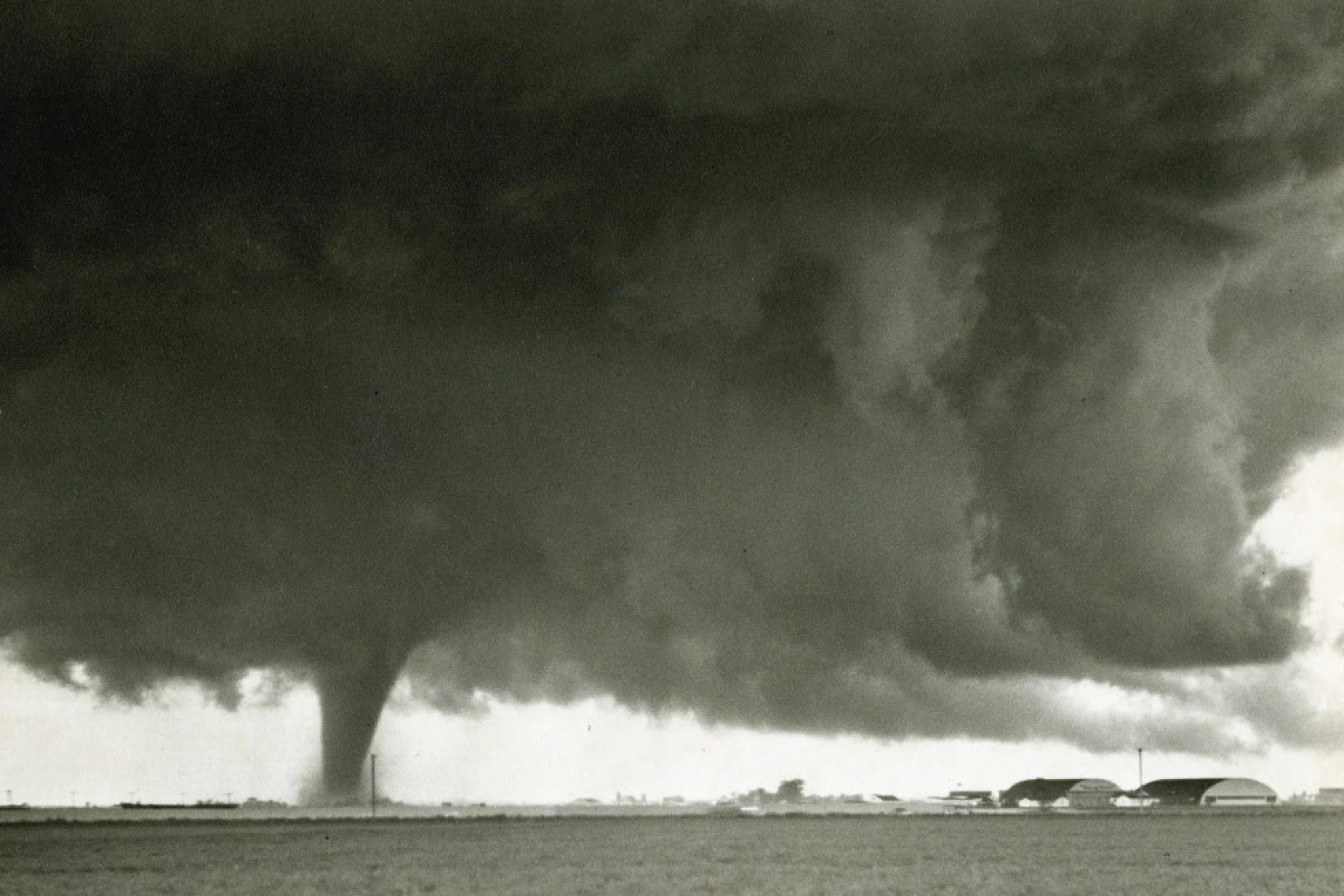
The Fargo tornado of 1957 was the third in a tornado family to move from Central North Dakota to Central Minnesota. Well known for being the most destructive and violent out of the family, the Fargo Tornado is also known for the deaths of the Munson family children where 6 children in one family were killed. The body of Jeanette is shown below, being carried by the 21 year old Richard Shaw. It was made worse knowing that these children stayed home, unable to escape the violent winds that would soon engulf the home, hiding under the kitchen table. Despite the insistence of their fellow neighbors earlier, they refused to leave, they had prepared a surprise birthday party for their mother. As it happened, Mercedes Munson had asked to get off work early, but the man who was to relieve her was half an hour late. Mercedes Munson was able to reach her 16-year-old daughter on the phone. But then the line abruptly went dead.
This tornado was the cornerstone of tornado research for Dr. Ted Fujita, Fujita would coin the terms “wall cloud”, “tail cloud” and “collar cloud” (NWS, 2019), which are still in use today. Likely if you've heard a series of words like this during tornado season, Fujita was probably the one who created it. He created new ways to research tornadoes such as including aerial photography and the use of satellite images and film. The 1957 Fargo tornado, despite being in an area not familiar to many Americans, was said to be the best documented tornado in history.


Extra reading:
https://nwafiles.nwas.org/digest/papers/2011/Vol35No1/Pg27-Schultz-etal.pdf
https://www.inforum.com/newsmd/60-years-later-fargos-1957-tornado-still-haunts
https://en.wikipedia.org/wiki/Tornado_outbreak_sequence_of_June_20%E2%80%9323,_1957
https://www.tornadotalk.com/fargo-nd-f5-tornado-june-20-1957/


- 4
- 24
A magnitude 7.0 earthquake occurred in Spitak, the Soviet Socialist Republic of Armenia (now Armenia) in 1988.
An earthquake was felt in central Armenia around 11 a.m. However, Armenia was originally located on the border of the Arabian and Eurasian plates like the other Caucasus regions, so earthquakes were frequent and people thought nothing of it and went back to their normal lives soon after preparing for an earthquake. However, a 7.0-magnitude earthquake struck Armenia at 11:41 a.m. The massive earthquake forced the collapse of stone houses, which were not designed to be earthquake-resistant, and destroyed downtown Spitak, where most of the buildings collapsed. People were forced to be trapped in the collapsed buildings without time to avoid the earthquake, which contributed to the damage.
Since then, the Soviet government has immediately sent rescue teams to the scene, but because the majority of the city had collapsed and the roads were no different, the rescue teams could not arrive early and eventually start full-scale rescue after taking care of the surroundings. However, because of its size, the Soviet Union unusually actively asked Western countries for help, and several Western countries sent rescue teams to the Soviet Union
The earthquake damaged an estimated 25,000 to 50000 people and an estimated 31,000 to 1300 people injured, and destroyed most buildings in the city of Spitak.
Since then, the Soviet government has been struggling to recover due to the Chernobyl nuclear power plant explosion, while Armenia has gained independence and has since been slow to recover due to internal problems and war, but most of it has been restored as Armenia's economic situation has improved.

What it looks like after the earthquake
South Korea also reported the earthquake as news.

- 6
- 38
What? Dickfart doing another post so soon? Yeah what you gonna do 'bout it.
In January 2024, two forest fires prompted the National Service for Disaster Prevention and Response to issue a red alert. One occurred on 20 January in Lonquimay, Araucanía Region, and another on 26 January in Puerto Montt, Los Lagos Region.
On 22 January, a fire, named "Antiquereo 2", broke out on the boundary of Portezuelo and Trehuaco in the Ñuble Region. It was contained by 24 January after consuming 35 hectares (86 acres). SENAPRED responded by declaring a yellow alert in Portezuelo, marking the first alert of the year in the region.
By the end of January 2024, a fire originating in Florida, Biobío Region, spread to Quillón in the Ñuble Region. The "Casablanca" fire, covering 69.5 hectares (172 acres) in the Peñablanca sector, was extinguished through collaborative efforts between the Quillón and Florida fire departments.
In the last week of January 2024, a heatwave hit central Chile, with temperatures 10 to 15 °C (18 to 27 °F) above the weekly average. Anticipating an increased wildfire risk, the Meteorological Directorate of Chile issued a heat alert on 28 January, projecting temperatures of 36 to 38 °C (97 to 100 °F) in valleys and foothills of the central zone and 30 °C (86 °F) on the coast of Valparaíso, O'Higgins, and Maule regions.
A total of 131 people were killed in the fires, of whom 35 have been identified so far. The Chilean Forensic Medical Service said many bodies were found to be in bad condition and difficult to identify, prompting them to take DNA samples from people with missing relatives. At least 45 of the dead were found at the scene, while six others died of burn injuries in medical facilities. At least 14,000 houses were affected by the fires in Viña del Mar and Quilpué. Over 370 people were reported missing in the Viña del Mar area alone, while 1,600 others were displaced by the fires. The fires were regarded as the deadliest in Chile's history, and the deadliest disaster in the country since the 2010 Chile earthquake.
In Valparaíso, four hospitals and three nursing homes were evacuated, and two bus terminals were destroyed. In Viña del Mar, the city's botanical garden, which was founded in 1931, was destroyed by the fires, killing an employee and three of her relatives.
President Gabriel Boric said the death toll was likely to rise.


- 33
- 230
[01.08.2022]
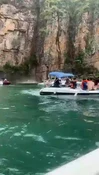
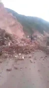
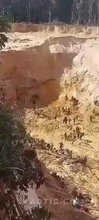
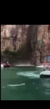
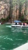
The collapse of a rock onto boats in the Capitol  region, in Minas Gerais, left at least eight people dead in the early afternoon of this Saturday (8).
A video  circulating on social
  media
media  shows the moment
  a large
  block
block  of stones collapses into the water
  of Lake Furnas, a tourist attraction in the region. The incident would
  have started with a “water head” in the canyon region, causing stones and rock structures to collapse, which hit at least three
  vessels — 2 sank.
At least 32 people were injured  in this accident. Among
  them, 23 were treated at Santa
  Casa de Capitolio with minor
  injuries and have already been released. Two other injured people, with open fractures, are being treated at Santa
  Casa in the municipality of Piumhi.
- 27
- 104
For me as a meteorologist for nearly 15 years now, going through extensive disasters such as the Black Saturday Bushfires back in 2009 here in Australia, to Super Typhoon Yolanda/Haiyan in 2013, no disasters has perked my interest as much as the 1999 Bridge Creek/Moore F5 Tornado (there are a few others such as Xenia 1974 and Jarrell 1997). This storm, if the fujita scale rating has gone up over F5, would be at F6. This was a beast. Unfortunately, I am limited in finding bodies of victims of this tornado, and others like it.
And of course, if you have personal experiences with disasters, let me know! I'm considering my future options in doing my doctorate and I would love a bit more research material for any future thesis or papers I plan on writing.
⛈️⛈️⛈️
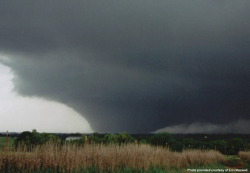
On May 3, 1999, one of the most infamous tornadoes in U.S. history rampaged central Oklahoma. The tornado was an F5, and it tore through the cities of Bridge Creek, Newcastle, Moore, and parts of the south side of Oklahoma City.
The tornado was part of a prolific early May tornado outbreak, which featured a vigorous upper-level low pressure system that moved into the Central and Southern Plains during the morning of May 3. Surface analysis indicated a dryline was located from Gage to Childress, Texas. By late morning, low clouds over northern Texas into Oklahoma started to dissipate as the dryline began to approach. A mix of sun and clouds took shape, which allowed the atmosphere to destabilize. The combination of sunshine and surface heating, and plentiful low-level moisture, led to a very unstable air mass. In addition, strong directional wind shear and cooling temperatures in the upper atmosphere indicated the atmosphere was primed for the development of tornado supercells.
Thunderstorms began developing in the late-afternoon hours as CAPE values over the southern Plains had reached nearly 6,000 J/kg. Large supercell thunderstorms formed too, and during the late afternoon to the mid-evening hours of May 3, tornadoes started to touch down across Oklahoma.
The powerful Bridge Creek-Moore Tornado was the 9th out of 14 tornadoes produced by a supercell thunderstorm during the tornado outbreak. It formed around 5:26 pm CST, about 2 miles south-southwest of Amber, Okla., and grew rapidly as it headed northeast, paralleling Interstate 44. It moved across Bridge Creek and rural parts of northwest Newcastle, producing continuous F4 and sporadic F5 damage. The tornado was estimated to be a mile in diameter at this time.
From there, the tornado moved through southern sections of Oklahoma City, to the northern sections of Moore, through Oklahoma City again, to Del City, and on into Midwest City. The twister claimed 36 lives, destroyed 1,800 homes, and damaged another 2,500, according to the National Weather Service. In fact, a Doppler on Wheels research radar measured a wind speed of 301 mph about 100 feet above the ground in that tornado, which was up to three-quarters of a mile wide.


Below are youtube videos as I was unable to upload them to the site.


- 17
- 91
DELETE THIS IF REPOST! MOVE IF THIS DOESN'T BELONG HERE!
Main part of the video starts at around 1:20.
The person recording the video (Clem Schultz) survived, however his wife on the first floor died along with his neighbor.
Text from the Wikipedia article about this particular tornado:
The disaster was captured on phone camera by Clarence "Clem" Schultz (85), who recorded the tornado from his home. Mr. Schultz survived with a compressed broken vertebra, but his wife, Geraldine "Geri" Schultz (67), and their neighbor, Jacklyn Klosa (69), were killed. The Schultzes' dog, Missy, and Clem's phone with the footage were found unharmed after the disaster. The footage which captured the tornado's approach and destruction of several houses (including the homes of Klosa and the Schultzes) was recovered and was released online and in news broadcasts as a cautionary example.


- 4
- 28
In 2015, a fire erupted at Formosa Fun Coast water park in New Taipei during the Color Play Asia event. Flammable colored powder led to a massive explosion.
15 lives were lost, and many got seriously injured in the chaos. The fire lasted only 40 seconds and burned 508 people. Investigations revealed safety negligence, leading to legal actions against park officials and contractors.


CHILD WARNING
EFFORTPOST
Eruption of volcano Fuego in Guatemala, June 2018. At least 201 people died 'officially' and around 12,800 were evacuated  Thumbnail: CBC news as an introduction. In the post: background, photos from the rescue operations and bodies [also videos!] - looking like statues buried in the eerie landscape [CW]
- 18
- 112
On 3rd of June 2018, volcano Fuego erupted the second time that year; that day started from a strong explosion in the early morning. It was the deadliest recent event involving Fuego. This post may be the first one on WPD to show the aftermath of a modern volcano explosion - I mean mostly the bodies, of course.
Sections go as follows:
1. Time, place and how it begun. Includes videos recorded by the witnesses, and some maps and technical details.
2. Aftermath. What was left of the villages and people (and a few animals) living there. Both photos and videos showing the corpses (including animals).
3. Landscape. What was visible only from the air.
4. Photos or videos from the rescue operations. Includes cute animals, this time not dead - from a horse through dogs to cats (you have to open the gallery I linked) and even chickens rescued by the firefighters and police.
⠀TIME AND PLACE 
First, the basic map:

And location of the most important communities (click to enlarge, it's nearly 5 MB):

Summit elevation: 3763 m.
Fuego was characterized by a moderate activity during the first two days of June. In the early morning of 3rd of June 2018, there was a strong explosion. The ash plume rapidly rose to 6 km altitude (above the sea level, not above the volcano). Large pyroclastic flows travelled down three ravines, and into two communities: Sangre de Cristo and San Pedro Yepocapa (west flank). Thorough the day, more strong explosions happened, producing additional large pyroclastic flows in six ravines and causing devastating damage to numerous communities around the volcano.
Two views of the pyroclastic flows. Specifically: 8 km E of the summit and 7 km SE of the summit.


Now, two videos. I don't know their very exact location. In the first, the cameraman and the rest of people watching did a really dumb thing - but we have this video, at least 
A brave Guatemalan dad and son drove several times toward the ash cloud after the Fuego volcano eruption to help people get down to safer zones on Sunday (June 3). Adrian Larios told Reuters he and his dad drove up 13 times until they got all the people who couldn't move fast enough to escape the lava. A video filmed by himself showed his dad driving and urging people to get inside the car as other people ran downhill on the street.
Video of firefighters trying to drive away from an ash cloud. That escalated quickly
Ash plume was fucking big.
The ash plume from a large explosion at Fuego on 3 June 2018 rose above the cloud cover to over 15 km altitude and was imaged by the Visible Infrared Imaging Radiometer Suite (VIIRS) on Suomi NPP at 1300 [1 PM] local time. Courtesy of NASA Earth Observatory.

Photo of what you've seen in a detailed map earlier.
The pyroclastic flows down the SE flank were especially devastating to the communities in their path, covering roofs and vehicles with ash and debris (figure 97-100) and killing scores of people. The communities of San Miguel Los Lotes about 9 km SE of the summit and El Rodeo (10 km SE), both in Escuintla Province, were severely damaged from the pyroclastic flows, with most of the fatalities and missing people reported from those communities.

On 3rd of June 2018, explosions stopped at early evening. Pyroclastic flow activity finally slowed down. Some communities had to be evacuated due to lahars - that's what is formed when the debris, ash and dirt mixes with water, creating a mudflows. On 4th of June, there were 5 to 7 weak explosions every hour, which means 'lower levels of activity'. Emergency was declared in all three provinces surrounding the volcano (Escuintla, Sacatepéquez and Chimaltenango). On 5th of June, there were 8 to 10 moderate explosions per hour, which resulted in increased number of the block avalanches. Two new pyroclastic flows led to evacuation of additional communities - seven in total - and closing Palín-Escuintla highway.
This photo was taken on 5th of June, 10 km SE of the summit, in El Rodeo community. It shows the additional pyroclastic flow.

⠀AFTERMATH 
Two videos, first one is small resolution and corpses are visible in the first part; second one shows digging the body from the rubble.
Title of this video mentioned looking for survivors, but seems there are corpses. CW here, there is rather stiff baby or toddler carried away in the beginning.
Unusually for the media, this time corpses were quite commonly depicted in the pictures, and not only by the agencies that usually show more gore than the others (e.g. AP).


It's harder to get photos with more corpses visible. I found this one on Facebook:

Other photos are scattered aroung the internet, including Documenting Reality. Some of them apparently were on Facebook, too.


Kids, news say they were from El Rodeo:


Duck, dog (in worse resolution) and a cow in affected zone:


Statistics from October 2019:
On 3 June 2018, Guatemala's 3,763-metre (12,346 feet) Fuego Volcano erupted, killing 201 people, injuring 27, and leaving some 260 people missing. The volcano emitted an eight-kilometre (five-mile) stream of hot lava and a dense plume of black smoke and ash that blanketed Guatemala's capital city and other regions. According to Guatemalan authorities, 12,823 people were evacuated from the affected area, of whom 1,398 remain in collective centres.
⠀LANDSCAPE 
La Reunión Golf Course and Residences on 7th of April 2017 and on 6th of June 2018:


San Miguel Los Lotes on 5th of February 2018 and on 6th of June 2018:


Drone view on El Rodeo community:
View from the helicopter (volume warning) on 4th of June:
Few clips from The Guardian, some of them is aerial footage:
⠀RESCUE OPERATIONS (PHOTOS/VIDEOS) 
I will put links to galleries here, as otherwise scrolling this post would take really long.
Carrying away the wounded:


Very nice gallery on The Atlantic site.
Some photos from animal rescue:
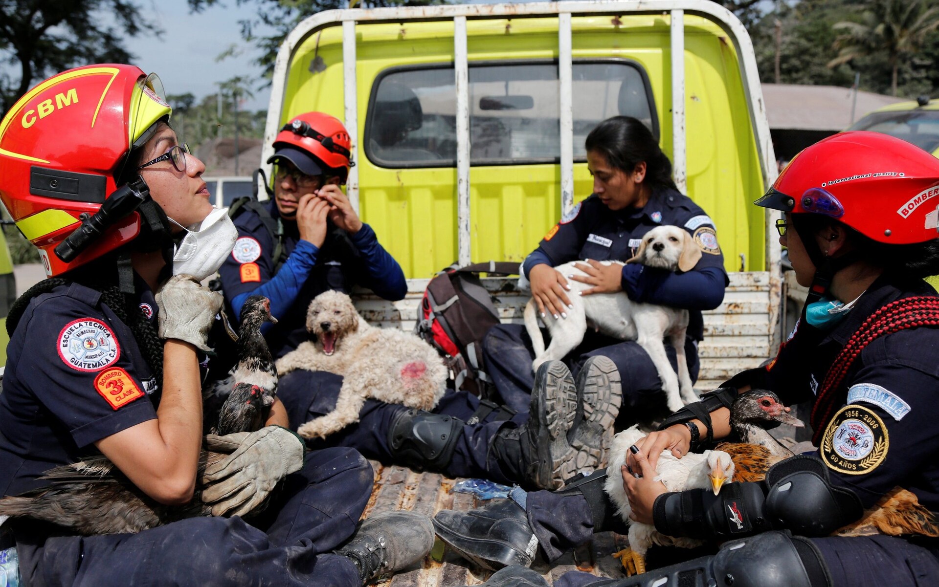


More photos showing animal rescue!
Wholesome video of firefighters with rescued hen and her baby chicks:
⠀SOURCES 
https://volcano.si.edu/showreport.cfm a really detailed summary of the activity of the volcano Fuego in 2018, on a website of The Smithsonian Institution's Global Volcanism Program (GVP)
https://www.nytimes.com/interactive/2018/06/07/world/americas/guatemala-volcano-eruption.html amazing map and 'before and after' photos for comparision!

- 194
- 791
woman in Peru what appear to be trying to stop a landslide by standing right in the middle of it while chanting periodic table. but she failed miserably, because nature doesn't work the way she intended, you can't control nature.
I'm bit confused where should I put this video on what flair, but maybe disaster is the most correct flair because the woman in the video killed by natural disaster, but it's up to admin I guess to decided.
as usual feel free to report in case this is a repost, but add the link to the previous video.
please help me get 1k special badges by reach 1000 upvote in this post.


- 17
- 77


 Vid showing the bodies (put on display for identification), others showing the searches and cleanup, whole section for animal rescue, and BACKGROUND!
- 19
- 200
I've accidentally found a video showing the bodies, likely left for the identification, claiming it's from this event. So it's a good opportunity to make you a post in this quite unpopular disaster flair. You've already had tl;dr in the form of the above news video. However, the mentioned death toll was later changed, and adding the missing persons (more likely the missing bodies), the mudslide could claim 409 victims. There is barely any gore in this post, actually, but I hope you will like it.
Reportedly, it was the first disaster when the animals were included in the emergency efforts. At least that was claimed on Twitter of the Animal Protection Society of Bogota. So I included you a few cute animals as a bonus!
⠀HOW THE EVENTS UNFOLDED? 
If you want to compare 'before' and 'after', go to the Google Street View. There is mostly June 2019 and March-May 2014 views available. Here a few pre-flood views from the city center:


From the scientific point of view, 'how did it happen?' was a subject of a few studies. Human rights activists were also pointing out another factors, and claimed that it was a 'foretold' disaster. But let's start from the beginning. At night from 31st of March and 1st of April 2017, a heavy rainfalls in Mocoa, southern Colombia, resulted in an avalanche of mud and water. This town is located in the Andes, and is characterized by tropical-mountain weather with high-intensity rainfall.
Heavy rainfall starting around 11 PM on 31st of March caused overflows in a few rivers, from which the three main are Rio Mocoa, Rio Sangoyaco and Rio Mulata. The landslides and river erosion provided a lots of debris for the river floods. A few separate ones resulted in a debris flow downstream in the Taruca ravine, northwest of Mocoa. The debris and floods were flowing at speeds of 56-64 km/h (or 34-40 mil/h). It, quoting, 'rushed resident buildings, streets, bridges, and other infrastructures. Massive debris and mud piled up in the city, with tree limbs, rocks, fencing, and vehicles in a disorderly mix'. As it were still pre-dawn hours, most of the residents were sleeping.
Here, more detailed map.

This one shows river overflowing effects:

Remote sensing images of pre-disaster and post-disaster. (a) Pre-disaster image (April 15, 2015). (b) Post-disaster image (April 10, 2017). (c) Overflowing rivers: ① the Rio Mocoa River, ② the Rio Mulato River, ③ the Rio Sangoyaco River, ④ the Quebrada Taruca River (two branches downstream: north-south, west-east), ⑤ the Quebrada San Antonio River, and ⑥ the Quebrada Taruquita River
⠀SEARCHES, MESS, CLEANUP AND CASUALTIES
The video in the thumbnail (attachment) was shared on 2nd of April. I was trying to look for a content from the 1st of April. I've found an RT article with quite a lot of content from the 1st of April. Credits for the quotes go to them!
Colombian President Juan Manuel Santos told reporters on Saturday that the area had experienced 130 mm (5 inches) rain overnight, when the average monthly rainfall in Putumayo region is 400 mm.
The Colombian Red Cross are currently unable to accept aid donations until a suitable staging area has been established and proper means of distribution organized.
Governor Sorrel Aroca told local media that 17 neighborhoods had been damaged by the flooding, with two bridges closed and electricity supply disruptions expected to continue, hampering emergency response efforts.
Posted in the early afternoon on the 1st of April.


A video from Instagram, hour not given.
Below, a Twitter video, if it shows my local time, then the original one was posted past 9 AM.
Their Ministry of Defence posted these photos on 1st of April.


Debris has been strewn across the city of 350,000 residents.
Photos from Facebook, and again, if it shows my time then these are from around 9 AM.


Photo from around 10 AM.

The Colombian military are on scene to assist with evacuations and relief efforts and a state of national emergency has been declared.


More rescue efforts from 1st of April, posted in the afternoon.


'Ejercito' means 'army'.
Undated:


⠀ANIMAL BONUS... 
Protección Animal Bogotá posted this on twitter:
Por primera vez los animales son incluidos en un plan de emergencias frente a un desastre, celebramos este gran logro.
"For the first time, animals are included in an emergency plan in the face of a disaster, we celebrate this great achievement."


This video was posted with a Spanish description, something like 'The others who survived', on 3rd of April.
Rescued dog:

Rebuilding a shelter for the sick animals (photos by Corazón Animal Putumayo):


Music warning:
⠀VIDEO SECTION
Here, video claimed to be showing the bodies, likely left for the identification. I don't know the time or where it was exactly and couldn't find it in another source.
A few news coverages. The Guardian:
Euronews:
Associated Press raw footage of clean-up.
An avalanche of water from three overflowing rivers swept through a small city in Colombia while people slept, destroying homes and killing at least 154 unsuspecting residents in their sleep, authorities say. (April 1)
The cleanup efforts in southern Colombia continued on Sunday, after surging rivers sent an avalanche of floodwaters, mud and debris through a small city, killing at least 200 people and leaving many more injured and homeless. (April 2)
AFP News Agency:
Families and friends of the more than 270 victims of the devastating mudslides in the Colombian town of Mocoa take part in an emotive mass burial for their loved ones, as survivors and rescuers keep up a bleak search for victims in the muck and debris.
⠀CAUSES AND THE ULTIMATE AFTERMATH 
The death toll was updated all the time, at least partially by the army.
According to the Single Victims Registry, the catastrophic event caused 332 deaths, 398 injuries, 77 people missing and 7794 families affected (Pontificia Universidad Javeriana, 2017; Cruz Roja Colombiana, 2018). In terms of infrastructure, the damage toll was 11 kilometers of destroyed roads, 1462 damaged houses, and the city's water supply system and power station were completely devastated.
The damage to structures caused by the 2017 Mocoa debris flows. The shading indicates the 2006 hazard map that formed the basis for land use planning.

Colombian President Juan Manuel Santos has faced criticism for the relief effort. He told the reporters that it is natural for those affected by the disaster to blame the government, though. According to him, that's because of climate change, caused by the richer countries. He defended his gov's response to the Mocoa landslide, claiming rescue agencies were brought together just hours after the disaster. The president also claimed that the rescue operations had no precedents:
He said new systems had been put in place following deadly floods in 2010 attributed to the La Niña climatic phenomenon.
"We have a system, which we have been elaborating and creating after the phenomena of La Niña, which was the worst natural disaster at the beginning of my government, and the system is working," Mr Santos said.
"We put in place a central command where all the institutions that are involved started to work 12 hours after the disaster. This is something we have never seen before either here or in any other countries around the region."
Mr Santos said the tragedy was a demonstration that climate change "has terrible effects".
[...] "The intensity of the rain - it rained in two hours what would usually rain in one month. That intensity produced the avalanche that is a direct product of climate change."
However, it was later brought up that the government actions could prevent some harm. It is indeed a gov's fault to allow urban development in places which are not suitable for it.
Government agencies, land use experts, and environmental organizations had said for years that Mocoa could face dangerous flooding. Many who lived in the most vulnerable areas were aware of the warnings, even if they didn't heed them. And yet the city continued to spread into the floodplains west of downtown.
“Unfortunately, in Colombia we don't have a good assessment of risk, or good land use policies to prohibit people from settling in areas like these,” said Marcela Quintero, a researcher with the International Center for Tropical Agriculture, one of the organizations that raised the alarm about deforestation in the area.
Mocoa was vulnerable because of its location, amid a confluence of rivers in the wet subtropical Amazon region of southern Colombia. The danger had grown worse as trees were cut for cattle ranching and other agriculture, removing protection against flooding and landslides. Then came an influx of new residents, many fleeing violence from the government's long fight with guerrilla forces.
⠀SOURCES
A lot of photos come from Twitter or Facebook.
https://www.bbc.com/news/world-latin-america-39499764
https://www.rt.com/news/383087-colombia-mudslide-mocoa-flood Content from the 1st of April.
https://link.springer.com/article/10.1007/s10346-018-0969-1
https://www.cbsnews.com/news/colombia-landslide-disaster-foretold-warnings-mocoa-flooding-mudslide

- 6
- 43
10 deaths and 32 non-fatal injuries
https://en.wikipedia.org/wiki/Capitólio_rockfall
Longer video with slo-mo of people sent flying:
Top Poster of the Day:
 reichsfuhrer
Deaths Today: 0
Current Registered Users: 2,107,435
 BROWSE EFFORTPOSTS
SITE GUIDE
PING GROUPS
BROWSE EFFORTPOSTS
SITE GUIDE
PING GROUPS
Disaster

When Mother Nature gets upset. Here you will find tsunamis, earthquakes, landslides, tornadoes, and so on, along with their deadly consequences.
 Slavshit

 Sandshit